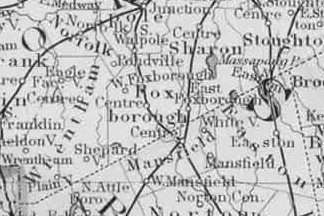
Maps Of Foxborough
Foxborough formally became a town in 1778.
Maps
Historical
* Pokanoket
* Wôpanâak/Wampanoag
* Massa-adchu-es-et/Massachusetts
General, Topographic, & Older Maps
More Recent Maps
Assorted

From The Commonwealth Of Massachusets
Place Names
From: Commonwealth of Massachusetts & Commonwealth of Massachusetts
| Unofficial name Donkeyville Foxvale Lakeview Paineburg Quaker Hill |
a locality in, or part of a Town(s) or CITY (in caps) Foxborough Foxborough Foxborough Foxborough Foxborough |
County Norfolk Norfolk Norfolk Norfolk Norfolk |
Also known as, or other notation now Lakeview a.k.a. Paineburg formerly Donkeyville a.k.a. Foxvale |
Foxborough's History And Historical Sites
- History / Home
- Cemeteries In Town
- Genealogy Information
- Historic Buildings
- Maps
- Military Service & Records
- People & Families

